The hidden history behind Menorca’s beaches, caves and coastal landscapes
The haunted shore of Menorca explained: Menorca’s darker, layered history is often hidden beneath the island’s postcard image of turquoise bays, white sand and quiet Mediterranean coves.
But beneath that image lies a different story.
Along its shores, Menorca is not just a place of beaches. It is a layered landscape where the dead were buried facing the sea, where coastlines were patrolled against invasion, where legends took root in caves, and where shipwrecks and trade routes still shape what lies beneath the water.
The island’s beauty is not separate from its history. It is the result of it. Menorca’s coastline functions as a layered historical system in which archaeology, trade, warfare, ritual and ecology remain physically embedded in the landscape rather than separated into isolated heritage sites.
The haunted shore of Menorca is not defined by ghost stories alone. It is shaped by prehistoric burial landscapes, maritime conflict, ritual sites, shipwrecks and centuries of Mediterranean coastal history layered directly into the island’s beaches and cliffs.
Why the haunted shore of Menorca still shapes the island
Nowhere challenges the postcard image of Menorca more clearly than Calescoves.
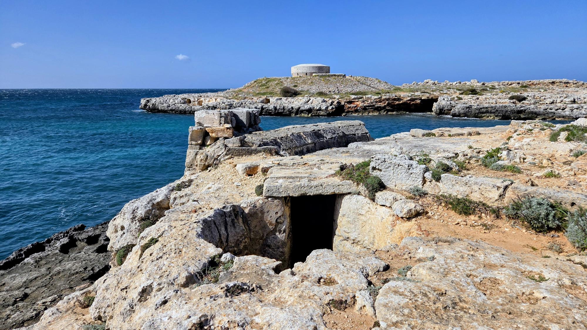
What appears today as a quiet, sheltered bay is one of the island’s most important archaeological landscapes. The cliffs surrounding the cove contain more than ninety burial caves cut directly into the rock. These range from natural cavities to highly structured hypogea, used over a period approaching 1,500 years.
For generations of prehistoric communities, this was not a place for leisure.
It was where the dead were placed above the sea.
Burials evolved over time. Early use included collective interments in natural caves, with bodies positioned in foetal form and accompanied by modest grave goods. Later, more complex chambers were carved into the rock, with richer artefacts and more formalised ritual practice.
Calescoves was not only a cemetery. It was also an anchorage, a settlement edge and a sacred landscape. The dead remained in direct relationship with the coastline, visible from the water and embedded into the cliff itself.
To visit it today is to step into a place where the shoreline has been used for both life and death for over a millennium.
Two coasts, one ritual landscape
If Calescoves defines the south, Cala Morell completes the picture in the north.
Here, fourteen artificial funerary caves overlook the sea, carved into white stone cliffs. These structures were used from the Bronze Age through to Roman times, forming a long-lived ritual environment.
Some of the larger caves functioned as collective pantheons. Bodies were interred alongside grave goods, sometimes covered in quicklime, with ceremonial spaces extending into forecourts where offerings could be left by the living.
One cave, often highlighted, features a façade influenced by classical decorative traditions, including elements associated with Etruscan and Punic styles. This reflects a wider Mediterranean cultural network influencing even remote coastal sites.
Taken together, Calescoves and Cala Morell establish a pattern.
These are not hidden inland tombs.
They are coastal necropolises.
For centuries, the dead were placed where they could face the sea.
Pirates, legends and surveillance
Not every story on Menorca’s coast is archaeological. Some belong to legend.
The most famous is Cova d’en Xoroi, a cave carved into the cliffs of Cala en Porter. Today it is one of the island’s best-known venues, operating as a daytime viewpoint, sunset bar and evening nightlife space.
According to local tradition, the cave was once home to Xoroi, a mysterious outsider who may have been a shipwreck survivor, a corsair or simply a fugitive. The story changes depending on who tells it. In most versions, Xoroi lived in isolation, survived by taking food from nearby settlements, and was eventually discovered after an unusual snowfall revealed footprints leading to the cave. The tale ends with him throwing himself into the sea.
There is no single historical version.
That is precisely the point.
This is folklore, preserved and repeated as part of the island’s identity.
The modern transformation of the cave into a commercial venue does not erase that history. It turns it into performance. Menorca has taken a story rooted in oral tradition and embedded it directly into one of its most visited coastal spaces.
The island that watched its own coastline
Beyond legend, Menorca’s coastline was a place of constant vigilance.
The Camí de Cavalls, now known as a scenic route circling the island, was originally a defensive system. Established in the 14th century, it required mounted patrols to monitor the coastline and respond to threats arriving by sea.
This was not symbolic. It was necessary.
Menorca’s position in the western Mediterranean made it vulnerable to raids, invasions and shifting imperial control. The coastline was both the island’s greatest resource and its greatest exposure.
In places such as Fornells, this vulnerability shaped settlement itself. The bay, naturally sheltered and strategically valuable, required fortification. Over time, watchtowers, castles and defensive infrastructure were constructed to protect it from repeated attack.
The town that exists today is inseparable from that history.
It grew where defence was needed.
The shock that reshaped the island
Menorca’s defensive landscape did not emerge slowly. It was shaped by moments of crisis.
One of the most defining was the 1558 sack of Ciutadella, when the city was attacked and devastated by Ottoman forces. Much of the population was killed or enslaved, and the event became one of the most traumatic episodes in the island’s history.
The impact extended far beyond Ciutadella.
It changed how the island thought about its coastline.
It reinforced the need for constant surveillance.
And it accelerated the development of fortified systems across bays, watchpoints and settlements.
Places like Fornells were not simply coastal villages.
They were part of a network designed to ensure that what happened in 1558 could not happen again unnoticed.
The shores where armies arrived
Menorca’s beaches were not only watched. They were used.
In April 1756, during the opening phase of the Seven Years’ War, French forces landed on the island’s western coast. Around 12,000 soldiers came ashore near Ciutadella, occupying the town and then crossing the island to besiege British-held positions in the east.
This was not a minor incident. It triggered one of the first major naval engagements of the war and led to the political collapse of Admiral John Byng in Britain.
Today, the landing took place in an area now associated with quiet coves and developed coastal zones. The contrast is striking.
The same shores used for swimming were once entry points for European conflict.
A coastline between empires
The 1756 French landing was not an isolated moment.
It was part of a much longer pattern.
Menorca changed hands repeatedly between Spanish, British and French control across the 18th century. Each period left marks on the coastline, from fortifications and naval infrastructure to settlement patterns and military roads.
The island’s geography made it strategically valuable.
Its natural harbours, particularly Mahón, were among the best in the western Mediterranean.
That meant control of Menorca was never only local.
It was European.
The beaches where soldiers landed, the bays where ships anchored and the paths that connected them were all part of a wider geopolitical system.
Today, those same places appear quiet and detached from conflict.
But historically, they were part of an island positioned at the intersection of competing powers.
The sea as an archive
If the coastline holds visible history, the water holds what cannot be seen.
Menorca’s seabed is now understood as a dense archaeological landscape. Hundreds of locations have been documented, including shipwrecks, anchorages and isolated finds spanning centuries of maritime activity.
In places such as Cala en Busquets, this history is layered in a literal sense. Excavations have revealed multiple overlapping wrecks from different periods, including vessels linked to medieval trade. The full chronology is still under investigation, making the site a rare example of an active archaeological puzzle.
Not a timeline, but a collision
What makes sites like Cala en Busquets particularly significant is not just the presence of shipwrecks, but how they appear.
Rather than a clean historical sequence, the seabed reveals overlapping remains from different periods. Vessels from separate centuries lie in the same confined space, creating a compressed record of maritime activity.
This is not a neatly ordered archive.
It is a collision of history.
Each wreck reflects a different moment of trade, travel or failure at sea, but taken together they show how consistently this coastline has been used and reused over time.
The result is a rare form of evidence.
Not individual events, but patterns of movement repeated across centuries.
Further north, near Sanitja and Cap de Cavalleria, underwater surveys have identified anchors and amphorae associated with Roman trade networks. These data points are not isolated discoveries. They are fragments of a wider system that once connected Menorca to the broader Mediterranean economy.
The sea around the island is not empty. It is an archive still being uncovered.
The haunted shore of Menorca is therefore not simply a collection of myths or isolated archaeological discoveries. It is a coastline where prehistoric ritual, maritime trade, military history and ecological systems continue to overlap visibly in the present.
Rituals that never disappeared
Not all of Menorca’s coastal rituals belong to the past.
Each year, communities gather for the maritime celebration of the Virgen del Carmen, the patron figure associated with fishermen. Processions move through harbours and bays, with boats following a ceremonial route and flowers cast into the sea in remembrance.
These events do not replicate ancient burial rites. They exist in a different cultural framework. But they show that the relationship between community and coastline remains active, visible and collective.
The sea is still a place of meaning, not just recreation.
A coastline that is still contested
Menorca’s relationship with its coastline is not only historical.
It remains active, and in some ways, unresolved.
The management of beaches, anchoring and marine ecosystems reflects an ongoing negotiation between use and preservation. The Posidonia meadows beneath the sea are central to that balance, both sustaining the coastline and placing limits on how it can be used.
In protected areas such as s’Albufera des Grau, these tensions are formalised through regulation, monitoring and enforcement. Anchoring restrictions, conservation zones and surveillance systems are not abstract policies. They are direct responses to the pressures created by modern tourism.
This makes Menorca unusual.
The same coastline that once required defence against invasion now requires protection from overuse.
The invisible layer beneath the beaches
The modern version of this relationship is often misunderstood.
Along many of Menorca’s beaches, dense accumulations of brown seagrass appear along the shoreline. To visitors, these can look like debris. In reality, they are Posidonia oceanica, one of the most important ecological systems in the Mediterranean.
Posidonia grows slowly and performs multiple functions. It supports marine biodiversity, stabilises the seabed and contributes directly to the formation and protection of sandy beaches. Without it, much of the coastline would begin to erode.
In some areas, the seagrass is temporarily removed during the summer season and returned later in the year to help protect against winter storms.
This creates a visible tension between expectation and reality.
What many visitors see as a nuisance is part of the system that makes the beach possible.
Why these stories matter now
It would be easy to treat these layers as separate.
Ancient burial sites.
Military history.
Local legends.
Environmental systems.
But on Menorca, they intersect.
The same coastal locations that held prehistoric cemeteries later became anchor points for trade, targets for invasion and now focal points of tourism and conservation pressure.
This continuity changes how the island should be understood.
These are not disconnected stories.
They are different uses of the same space over time.
And that is what makes Menorca distinctive.
A coastline defined by layers
Menorca’s shoreline is not defined by a single narrative.
It contains archaeological sites that span millennia, defensive systems built in response to threat, legends that have shaped cultural identity, and environmental processes that determine whether the coastline can exist in its current form.
These layers do not compete.
They coexist.
That is what makes the island different.
People come to Menorca for its beaches.
What they encounter, often without realising it, is a coastline shaped by death, defence, trade, ritual and ecology.
What makes Menorca unusual is not only the survival of these layers, but how closely they remain connected to the modern landscape experienced by residents and visitors today.
The haunted shore of Menorca therefore survives not as mythology alone, but as a visible historical landscape that still shapes how the island is experienced today.
That is the real story of the island.
Common questions about Menorca’s coastal history
Are there ancient burial sites on Menorca’s beaches?
Yes. Sites such as Calescoves and Cala Morell contain extensive funerary caves carved into coastal cliffs, used for burials over many centuries.
Is Cova d’en Xoroi based on a real person?
The story of Xoroi is a local legend rather than a verified historical account. Different versions exist, but it remains part of Menorca’s oral tradition.
Did armies land on Menorca’s beaches?
Yes. French forces landed near Ciutadella in 1756 during the Seven Years’ War, using the island’s coastline as an entry point.
Why is there seaweed on Menorca’s beaches?
The material is Posidonia oceanica, a seagrass that plays a crucial role in maintaining beach structure and protecting the coastline from erosion.
Why is Menorca’s coastline considered historically important?
Menorca’s coastline contains prehistoric burial caves, defensive systems, shipwreck sites, maritime trade remains and cultural traditions that span thousands of years of Mediterranean history.
Why is Menorca called the haunted shore?
The phrase refers to the island’s layered coastal history, including prehistoric burial caves, pirate legends, military landings, shipwrecks and maritime folklore that remain connected to the modern landscape.
Are there ancient burial sites on Menorca’s beaches?
Yes. Sites such as Calescoves and Cala Morell contain extensive funerary caves carved into coastal cliffs, used for burials over many centuries.
Is Cova d’en Xoroi based on a real person?
The story of Xoroi is a local legend rather than a verified historical account. Different versions exist, but it remains part of Menorca’s oral tradition.
Did armies land on Menorca’s beaches?
Yes. French forces landed near Ciutadella in 1756 during the Seven Years’ War, using the island’s coastline as an entry point.
Why is Menorca’s coastline considered historically important?
Menorca’s coastline contains prehistoric burial caves, defensive systems, shipwreck sites, maritime trade remains and cultural traditions that span thousands of years of Mediterranean history.
Why is Menorca called the haunted shore?
The phrase refers to the island’s layered coastal history, including prehistoric burial caves, pirate legends, military landings, shipwrecks and maritime folklore that remain connected to the modern landscape.